
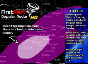
Good morning NTX. To start this forecast post we have a chance for some winter precipitation across the area late this afternoon into early Sunday. In this graph s large majority of thr area has the potential to see freezing drizzle and or sleet late this afternoon into early Sunday. The most likely areas to see freezing rain/sleet activity will be in the white shadded areas, where travel impacts will be possible (especially on bridges/overpasses, or untreated side roads where surfaces may become slick)
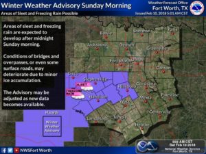
A Winter Weather Advisory will be issued late tonight around midnight and stay in effect until 12pm Sunday forthe areas shadded in purple. Once again travel impacts will be most likely in these areas South and South West of DFW.
We’ll continue to monitor the forecast. Stay tuned for the latest
Leave a Reply