
FOR DFW:
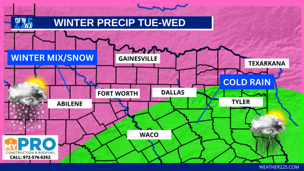
In DFW we have a chance for some winter-mixed precipitation and light snow across parts of the area, mainly along and north of I-20. Areas south of I-20 and southeast of the metro may see some mixed precipitation at times, however, a cold rain looks like the main precipitation type for areas south/southeast of the metro.
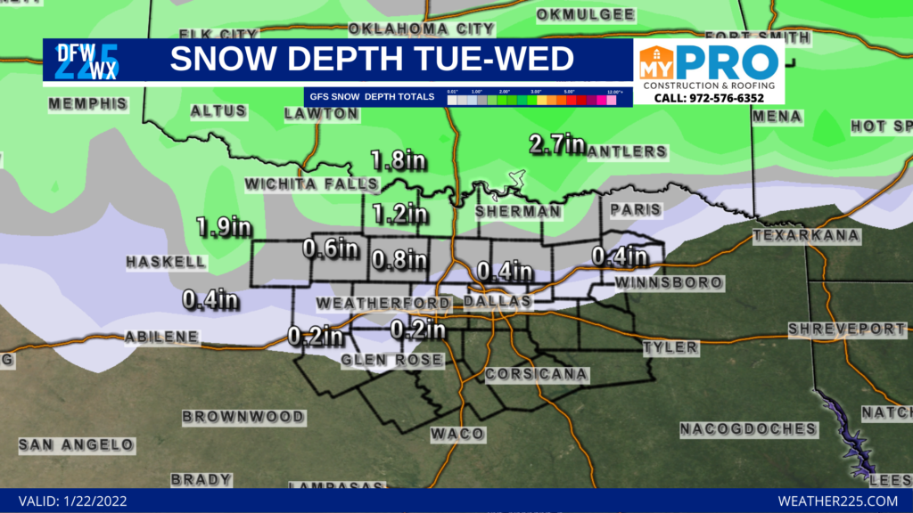
Here’s a look at projected snow depth across the area Tuesday through Wednesday. Why not look at snow totals with the models? The models so far have done a fairly good job with certain aspects of this system, helping us forecast this event, however, they have struggled with overall totals showing some dramatic outcomes, and not accounting for surface heating and other factors that will likely keep accumulations very light across the metro area. Snow depth gives us a more realistic view of how much snow may fall and how long it will stick around. As you can see, the current projection with snow depth shows us there could be a light dusting across the metro, with higher accumulation totals for areas north along the Red River.
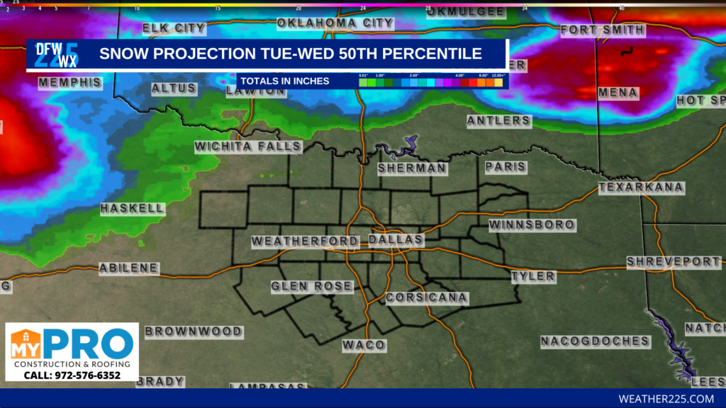
Some other ensembles are showing our coverage areas could see flurries and mixed precipitation falling, with little to no accumulations possible, such as our winter 50th percentile accumulations model. Stay tuned for updates as this forecast is day-to-day.
However, in our opinion, based on projected surface temperatures TUE-WED across the metroplex, the 50th percentile model may be more realistic, as surface temperatures look to be above to well above freezing for both days across all ensembles at this time, including the NAM model, which has typically shown colder than forecasted temperatures.
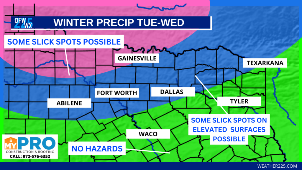
As of now it appears that widespread travel impacts look low to very low from this system across the metro area, with slightly higher probabilities of slick spots for areas northwest of the region mainly along the Red River.
Fayetteville Arkansas and Northwest Arkansas:
For the Northwest Arkansas viewing area, unlike our DFW viewing area, could see some potentially significant accumulations in some areas TUE-WED. We’re keeping an eye on some factors that could make or break the forecast for NWA, including, some potential additional disturbance’s that could interact with this system, and the overall main track of this system as it approaches the region.
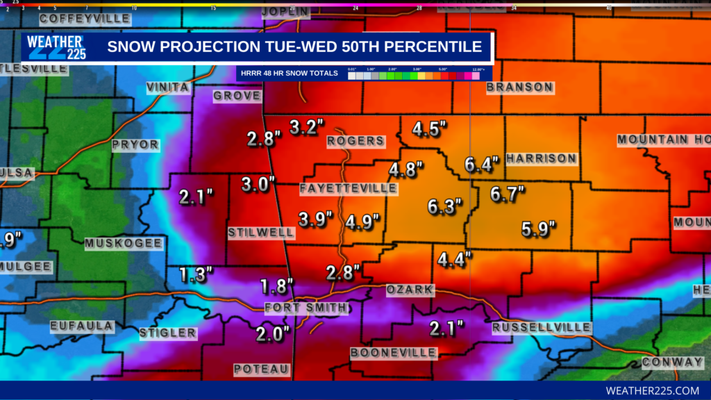
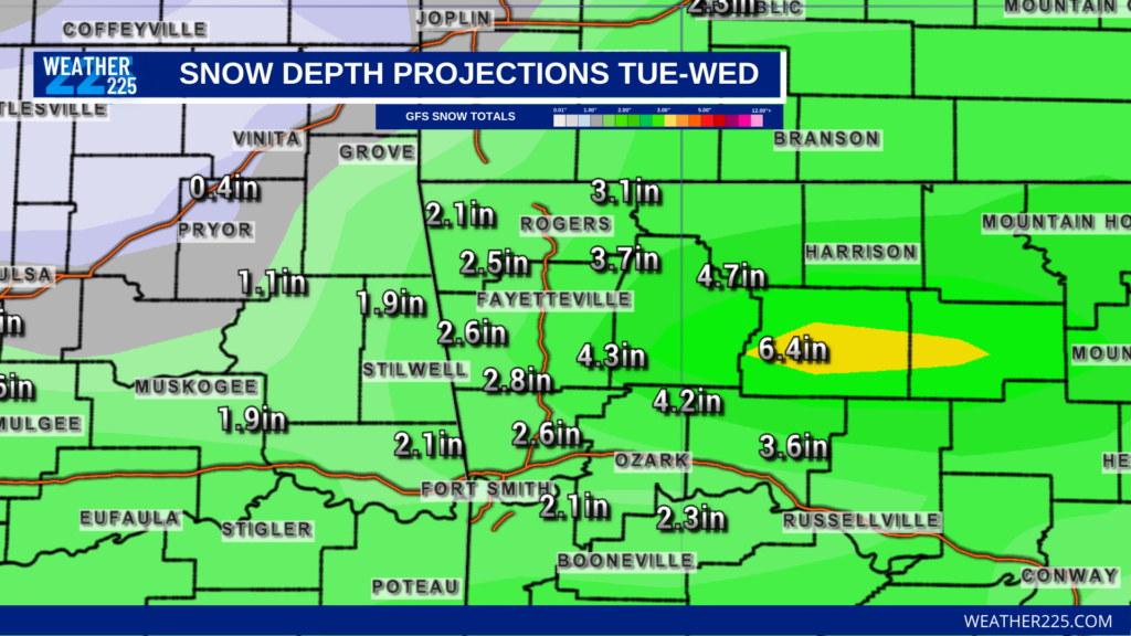
Current model runs and ensembles point toward 2-6″ of snow across the area, with higher amounts in elevated regions such as the Boston Mountains. For the River Valley as it looks now, there could be totals near 1-3″ in some areas. Like we did for DFW, we’re mainly looking at snow depth on the GFS instead of 10:1 model totals mainly because the models are having problems factoring in certain conditions and pieces to this forecast. Current 10:1 projected outcomes for instance, show anywhere between 12-17″ of snow across NWA, however, the 50th percentile ensembles and snow depth models are showing more realistic projections of between 2-6″. Snow depth gives us a more realistic view of how much snow may fall and how long it will stick around.
Travel hazards for the NWA area look likely as freezing temperatures and higher accumulations could lead to slick spots on area roads, especially in higher elevation areas. Check back for additional updates regarding the forecast and travel hazards.
Stay tuned to the forecast for updates as things can and will certainly be adjusted over the next 24 hours. Winter is one of the hardest things to predict, and these forecasts are day-to-day. Any slight adjustments could change the forecast greatly, so its always good to check back for updates from trusted sources. And remember some models will show some extreme accumulation totals, and some outlets may post these images as if it’s a set-in stone expected outcome, without factoring in parts to the forecast that give us more realistic look ahead. Don’t fall for media hype, stay tuned to trusted forecasters and Weather 225.
-Joshua W
Leave a Reply