
Good afternoon/evening NTX, we have a quick interesting forecast to discuss for tomorrow. To start another cold front will push through the region tomorrow afternoon bringing lower temperatures and a chance for storms along with some winter precipitation possible. Temps should stay in the 40s across DFW however for outer areas around NTX temps will reach near or at freezing during the mid to late afternoon hours. Winter precipitation (possible freezing drizzle, or some sleet) will be possible for our red river counties and areas shaded in pink on this graph from the NWS. As of now the likely hood of any potential winter travel impacts are in known, however we will continue to monitor the forecast.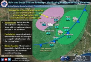 Now the other potential weather hazard could be an isolated strong wind and hail threat with storms on the eastern half of NTX tomorrow afternoon, where temperatures will be slightly warmer in the mid to lower 50s. The SPC has placed parts of NTX from areas from Paris to Plano to Arlington to Lake Whitney and areas east under a (1/5) Marginal risk for the possibility of a few strong storms. As of now the best timing for storms would be from 4pm-8pm.
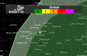
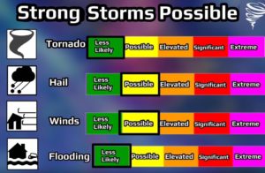 Widespread severe weather is not anticipated. We will continue to monitor the forecast and post another forecast if anything changes. Until then enjoy your evening NTX!
Copyright © 2024 | WordPress Theme by MH Themes
Leave a Reply