
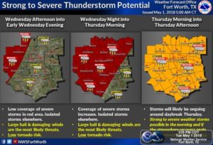
Starting tomorrow we could see storm chances start to increase. By this we mean the late afternoon/overnight hours Wednesday into early Thursday. The cap tomorrow should be quite strong and keep any development at bay across ohr area, as it appears at this time it would take temperatures to reach near 100 to break the cap, so we should stay dry during the day. Tomorrow night however as storms develop into west Texas the cap should be weaker tomorrow night, and any development as it pushes east could reach the metroplex early Thursday morning, however this activity should weaken and not be as strong. A slight risk is in place tomorrow for the possibility of storms overnight Wednesday into early Thursday. Storms that enter the region overnight Wednesday and early Thursday could produce strong winds if they merge into a line as they push east.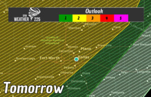
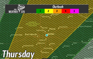
The atmosphere will be very unstable tomorrow, and this instability would carry into Thursday, however storm development will be determined by the activity Thursday morning, and how fast the atmosphere will recover for Thursday afternoon. A slight risk is in place for Thursday as well. So once again re-development in the afternoon will be possibly however the sevarity will be determined by storms Thursday morning
See our previous post about the Cap or “Lid” that we mention during forecasts like this, and how it works and effects the weather in the link bellow
Check back for the latest
Leave a Reply