
Good afternoon NTX and Merry Christmas! To start we’re going to talk about tomorrows storm chances. Tomorrow marks the 3 year anniversary of the Dec 26 2015 Rowlett Tornado, and with that fresh off most of our minds, we’d like to let those know who are worried about storms on thus day once again that we’re not expecting a repeat at all of 2015. It’s not unusual to have storms this time of the year, the two most memorable events would be of course Dec 26 2015, and Dec 29 2006 (some NTX history for you). Some of the differences between this set up and December 25 of 2015 would be surface temperatures and dew points for starters. On the 26th of 15 if you’ll remember, had surface temperatures in the 80s! Near record highs along with incredible dew points reaching the 70’s causing very strong instability in the atmosphere. Where tomorrows set up dew points will barely reach 60, with temps in the lower 60’s.
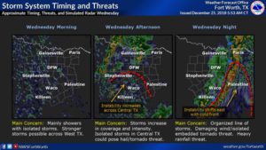 Instability will be more favorable for all types of severe weather the further south you go, however that doesn’t mean the DFW wont see storms, you’ll want to stay weather alert tomorrow. All types of severe weather will be possible tomorrow however this is starting to look of more of a wind and isolated imbedded tornado threat as storms should eventually form into a squall line as they push through the region. Heavy rain may also become an issue as heavy rain may cause some isolated areas of flash flooding. Timing I would say (as of 12pm the 25th) between 6pm-3am.
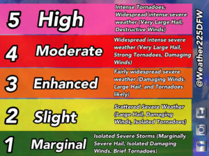
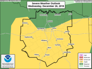 The SPC as of today has most of NTX along and south of the DFW and I-20 line under a Slight (2/5) risk for storm coverage. See graph bellow if you’re new to the SPC terminology 🙂
 And as always check back with me here at weather 225 for updates as we get new information, and you can always use our website for forecasts live free interactive radar and more! Have a Merry Christmas! 🙂

Leave a Reply