
Hey north Texas! We’re headed into February, and each day we get closer and closer to the start of “spring storm season”. To many who are new to the area, you may not understand the terminology we use during any severe weather set up or what exactly to expect during the spring.
To start severe weather can occur at any time of the year January through December, however, the most active months for severe weather in north Texas are March through June. Here are a few tips and paragraphs on terminology and other helpful things to help you understand and prepare for this storm season.
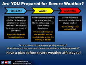
Watch, Warning, and Forecast- The beauty of technology brings forecasters the ability to forecast days in advanced of any potential event. However long range forecasts are not 100% accurate days out from any set up, still they can provide for us a glimpse of what we could see so we can let you know if there is any sort of potential in advanced so you can have time to prepare. When a forecast is issued it means sometime in the coming days forecasters anticipate that conditions may be favorable for severe weather development, and we will usually mention the SPC (Storm Prediction Center) and their “outlooks” and let you know there is a potential or likely threat of storms in the near future. When a Watch is issued, it means conditions are favorable for the development of severe weather in the coming hours, and that you should stay alert and ready to take action for storms. There’s 2 main types of watches we’re used to during the spring time 1 severe thunderstorm watch’s and 2 tornado watch’s. Both indicate that conditions are in place for the development for severe weather, the first is usually issued if conditions are more favorable for severe weather types such as damaging winds and hail, the second is issued when all types of severe weather including tornadoes is possible.
How can you stay informed and receive alerts? There’s many different ways to stay informed during the spring storm season. The 3 main ones I recommend are 1 certain alert apps, 2 NOAA weather radio, or 3 text alerts. The overall best option of the 3 is the NOAA weather radio, why? Because it is the best way to receive alerts immediately, straight from the NWS, and you can set most to alert only for specific locations you program which is helpful and possibly life saving during overnight set-ups, and most are battery powered and or crank powered to keep you alert in the event of a power outage. Some alerts app’s I personally use (for iPhone) are Baron Critical Weather (free on the app store) and Weather Radio by WDT ($3.99 on the app store I believe is how much I paid) Storm Shield is a similar app that works just as good (around the same price on the app store) both apps can send you alerts as soon as they are issued with a specific alert tone that’s not horrific or annoying but gets your attention. Here is a list of third party weather notifications recommended by the NWS, however do not rely on these alone to bring you potentially life saving alerts during storm season. It is always a good idea to have numerous ways of receiving warnings
What should I do if I’m in a warning? Always heed and take severe weather precautions when a warning is issued for your area. When a warning is issued they aren’t issued for certain counties entirely, they’re issued and marked by polygon lines on the map for certain parts of a county/counties where a storm is tracking. If you happen to be in the warning polygon you should always take action! If a Tornado Warning is issued you should always seek shelter quickly in a storm shelter or basement away from windows if you have access to either, still if you do not have access to either, seek shelter on the lowest floor of a sturdy structure away from windows in an interior closet or bathroom, put as many walls between you and the outside world as possible! For extra safety for the potential danger from flying debris cover yourself with pillows, blankets, or a mattress, as well as wearing a helmet if one is accessible. NEVER try to ride out a tornado in a mobile home or vehicle, seek shelter in a sturdy shelter, if no feasible shelter is available, lye flat in a ditch and cover your head. If a Severe Thunderstorm Warning is issued, you should seek shelter indoors and away from windows as hail or blowing debris could smash windows


How to avoid over hyped forecasts online- During severe storm season you may see a handful of pages that post what we call “hyped forecasts”, this is when a non trained individual or someone who knows little about models or forecasting in general look at certain models days out marked with “supercell composite” or sig tornado parameters” and see bright colors or Skew T readings with a higher tornado rating and chose to post this and cause unnecessary hype or fear. There is a lot more than looking at 2 model products that goes into any forecast, you have numerous other factors, temperature, CAPE, shear, front or disturbance alignment and position, winds aloft and many more factors, these are only a few to mention, not to mention there is lots of uncertainty forecasting for something days out! Sometimes we wont really know what to fully expect until literally hours before said set-up because of conditions that day that are uncertain or the CAP is on the weak of breaking, as we’ll mention further into this post. As someone who grew up terrified to the point of becoming violently sick from the thought of severe weather I don’t enjoy hyped forecasts for views and attention, I know that terrified and anxious feeling over the thought of mother nature’s fury, so I will always keep posts conservative and give you the straight forward facts on what to expect, if we ever hype up a forecast you know it must be important. To avoid “hyped forecasts” and peace of mind if you have anxiety from the thought of storms, always trust certified or trusted forecasters and groups such as the NWS, local News meteorologists, or trusted pages online.
“Outlooks”- During storm season you will hear us mention “SPC outlooks” a lot. The SPC (storm prediction center) issues outlooks daily for areas where they believe where the most likely areas for severe weather development and coverage will be, these outlooks have areas shaded in specific colors where they believe the best coverage will be located on a 1-5 scale. Here is their colors and meanings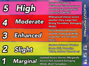
What makes severe weather occur? Severe weather occurs when favorable conditions combined with moisture from the Gulf of Mexico collides with a disturbance, front, or boundary. While severe can occur any day at anytime, typically severe weather occurs more frequently during the afternoon hours, when daytime heating is up, and warmer temperatures provide more lift in the atmosphere
The “CAP”- You will hear us mention a few times most likely during this season “the CAP”, but what is the cap? the cap is a layer of warm stable air closer to the ground that covers above our atmosphere in NTX that cuts off storm development, its typically strongest when its the night time or early hours of the day, and generally weaker in the afternoon hours when daytime heating occurs, unless there’s lack of sunlight or mid level warmer air moves over cooler ground level air. The cap cuts off warm rising air from the ground as the rising air is met with a layer of air at greater or equal temperature higher in the atmosphere cutting off its lift. When a cap is “weak” or “breakable” it’s when there is a slight temperature difference between the surface and the cap layer of air, if the surface temperatures exceed the temperature of the air forming the cap, the cap is then broken leaving the atmosphere vulnerable to the development of storms.
This concludes our post on severe weather safety, if you would like to learn more about severe weather click here for some more safety tips on all types of severe weather. And keep up to date with forecasts, alerts, and updates with Weather 225 🙂
- JW
Like!! Really appreciate you sharing this blog post.Really thank you! Keep writing.
I could not resist commenting. Perfectly written!
Do you mind if I quote a few of your articles as long as I provide credit and sources back
to your website? My blog is in the very same niche
as yours and my visitors would genuinely benefit from a lot of the information you present here.
Please let me know if this alright with you.
Thank you!
Hello, every time i used to check web site posts here in the early
hours in the break of day, since i like to learn more and more.
i like this recommended post
I seriously love your website.. Very nice
colors & theme. Did you build this amazing site yourself?
Please reply back as I’m attempting to create my very
own site and would love to learn where you got this from or what the theme is named.
Cheers!