
Good morning NTX, today’s weather headlines are for the chance for multiple rounds of storms later today through Sunday. To start this forecast, expect a warm humid day today with highs in the 80s and mostly sunny to partly cloudy skies.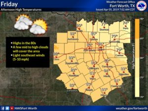
For today’s storm chances however, storm activity will remain west of I-35 where a (1/5) marginal risk is in place for some of our western counties. Large hail and damaging winds would be the primary hazards with these storms. This will be the first round of storms this weekend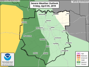
The second round of storms will be tomorrow throughout the day as all of the region we cover is under a (2/5) slight risk for storm activity. During this time all types of severe weather will be possible (large hail, damaging winds, and a few isolated tornadoes possible). You’ll need to keep an eye on Saturday and Sunday if you have any weekend plans. On top of the threat for severe storms, flash flooding may also become an issue as heavy rain from thunderstorms may cause isolated flooding in some spots that are prone to flash flooding
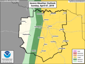
The third round for storms will be Sunday, as once again a large majority of the area, mainly east of I-35, is placed under a slight (2/5) risk for storms. During this time all forms of severe weather will be possible, however the primary threats would be damaging winds and large hail. Once again heavy rain will be a threat and could bring a threat for localized flash flooding

Here’s a general timeline for storms this weekend from the NWS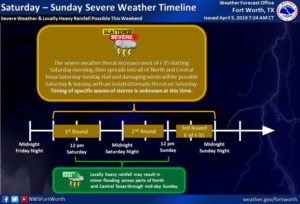
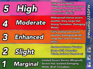
Now would be a good time to review your severe weather safety plan as there is a chance for multiple rounds of severe weather this weekend. If you’re confused with our terminology of the risks here’s a graph of what the colored outlooks mean issued by the Storm Prediction Center

And be sure to check back with us for the very latest!
Leave a Reply