
Good After noon NTX we’re tacking a chance for strong storms across the region tomorrow. To start this forecast I’ve mentioned how I believed that (based at the time) models the threat for severe weather would remain east of the Dallas, to Sherman line into east TX. However, as we’ve mentioned forecasts can drastically change before any said date especially with long rage forecasts. Today models and conditions have shifted our area of concern further west including all of DFW in either a (2/5 yellow Slight) or (3/5 orange Enhanced) risk for storms tomorrow afternoon and evening. However I’m holding onto the few models still showing activity staying east of DFW. Either way you need to remain alert and checking on the forecast as we head into tomorrow. Our greatest concern is not the risks involved its the fact that people don’t always anticipate or think about severe weather occurring at this time of the year, and are often caught off guard when there is a risk. To be clear this is perfectly normal for storms to occur this time of year.
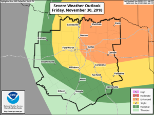
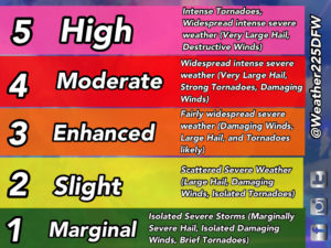
Now what’s going on now? The SPC has now expanded the outlook west including all of DFW in either a Slight (2/5) or Enhanced (3/5) risk for storms, and have even placed a “significant” risk area across the DFW area and areas north and east. This “significant” risk shows where the greatest concern is anticipated for development (at this time).
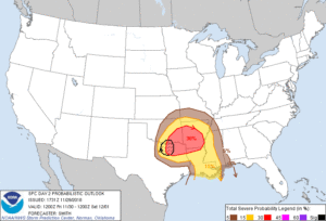
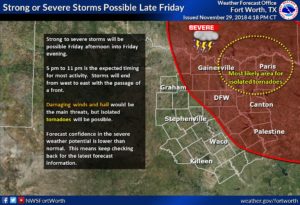
This risk is the result from an upper level disturbance coming in at a negative tilt (strong orientation/position), this will likely fire up some strong storms tomorrow afternoon and evening. The risks will be for some very large hail, damaging winds and “several” tornadoes possible. Todays updated forecast showing higher severe probabilities further west of the originally anticipated areas, so now along and east of the I-35 corridor. The timing currently looks to be from 5-11pm tomorrow
SPC forecast-
Farther west, the global models (EC, GFS) suggest initial convective
 development west of I-35 in north-central TX during the 22-00Z
 period as the leading edge of stronger deep ascent/DCVA overspreads
 the Red River Valley. The 12z/29 deterministic members of the HREF
 ensemble suggest little if any convection near the DFW metro prior
 to 00z. The 12z/29 NAM appears to be driving the HREF-based
 solution with storm development farther east within the warm
 conveyer near the Arklatex during the late afternoon. This forecast
 update is trending higher severe probabilities farther west near
 I-35 based on the EC/GFS/RAP suggesting warmer surface temperatures
 compared to a too-cool solution by the NAM. Once storms develop,
 the stronger updrafts will likely evolve into supercells capable of
 large to very large hail. A couple of tornadoes are possible
 especially as 0-3 km shear increases during the evening as 700mb
 flow strengthens in excess of 50 kt. Very strong 500mb 12-hr height
 falls (90m-150m) in the 00-06z period suggest upscale growth into a
 convective band will likely occur with the risk for damaging winds
 increasing along with a tornado threat continuing and spreading east
 into the lower MS Valley region overnight.
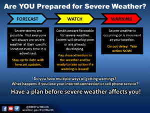
Now wouldn’t be a bad idea to go ahead and review your severe weather safety plan. The primary concern will be for very large hail possible, along with a couple of tornadoes possible and damaging winds with the strongest storms, as stronger updrafts could lead to the development of supercells. Because there is a higher end risk, or just a risk in general our main concern is that people aren’t paying attention to the forecast because we’re entering the holiday season and severe weather is the last thing on most’s mind.While this isn’t a historic set up by any means, it is still a risk and we just want you to be prepared in advanced incase storms develop. Not everyone will see storms. And remember anything can happen before tomorrow to the forecast, so stay tuned to NWS, other local trusted forecasters, and Weather225 for the latest, but for now we hope you have a great rest of your day 🙂

Leave a Reply