
(NOT DFW) the SPC has issued a PDS Tornado Watch for parts of Tennessee, Mississippi, and Alabama. For those who dont understand the term PDS, this means Particularly Dangerous Situation. The threat for significant long track or violent tornadoes is high within the watch area. And an outbreak is likely across the moderate risk area this afternoon and evening. Please if you or someone you know is in these areas, stay tuned to the local NWS or news broadcasters for the threat of significant severe weather this afternoon and evening across TN, AL, MS, and parts of GA. Potentially life threatening weather is likely across the watch area this afternoon and evening! People need to heed any warnings issued this afternoon and evening! Make sure you have ways to receive warnings, we recomend NOAA weather radio, and applications like Weather Radio by WDT on the AppStore.
Watch summary from the SPC. You can find the following and more on www.spc.noaa.gov
URGENT – IMMEDIATE BROADCAST REQUESTED
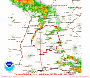
Tornado Watch Number 13
NWS Storm Prediction Center Norman OK
325 PM CDT Mon Mar 19 2018
The NWS Storm Prediction Center has issued a
* Tornado Watch for portions of
Northern and central Alabama
Northeast Mississippi
Southern Tennessee
* Effective this Monday afternoon and evening from 325 PM until
1100 PM CDT.
…THIS IS A PARTICULARLY DANGEROUS SITUATION…
* Primary threats include…
Several tornadoes and a few intense tornadoes likely
Scattered large hail and isolated very large hail events to 3
inches in diameter likely
Scattered damaging wind gusts to 70 mph possible
SUMMARY…Several severe storms will develop along a cold front
through this evening producing strong tornadoes, very large hail,
and damaging winds.
The tornado watch area is approximately along and 95 statute miles
north and south of a line from 15 miles south of Tupelo MS to 45
miles northeast of Gadsden AL. For a complete depiction of the watch
see the associated watch outline update (WOUS64 KWNS WOU3).
PRECAUTIONARY/PREPAREDNESS ACTIONS…
REMEMBER…A Tornado Watch means conditions are favorable for
tornadoes and severe thunderstorms in and close to the watch
area. Persons in these areas should be on the lookout for
threatening weather conditions and listen for later statements
and possible warnings.
&&
AVIATION…Tornadoes and a few severe thunderstorms with hail
surface and aloft to 3 inches. Extreme turbulence and surface wind
gusts to 60 knots. A few cumulonimbi with maximum tops to 500. Mean
storm motion vector 25040.
…Grams
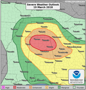
Public Severe Weather Outlook Summary
PUBLIC SEVERE WEATHER OUTLOOK
NWS STORM PREDICTION CENTER NORMAN OK
1141 AM CDT MON MAR 19 2018
…Severe thunderstorms expected over parts of the Tennessee Valley
this afternoon and tonight…
* LOCATIONS…
Northern Alabama
Far northwest Georgia
Far southern Middle Tennessee
Extreme northeast Mississippi
* HAZARDS…
Several tornadoes, a few intense
Scattered large hail, some baseball size
Isolated damaging winds
* SUMMARY…
Strong tornadoes, very large hail, and damaging winds are
expected across parts of the Tennessee Valley and Southeast
during the late afternoon and evening.
Preparedness actions…
Review your severe weather safety procedures for the possibility
of dangerous weather today. Stay tuned to NOAA Weather Radio,
weather.gov, or other media for watches and warnings. A tornado
watch means that conditions are favorable for tornadoes to form
during the next several hours. If a tornado warning is issued for
your area, move to a place of safety, ideally in a basement or
interior room on the lowest floor of a sturdy building.
~JW
Leave a Reply