
Latest model runs are coming in this evening for tomorrow afternoons storm risk. Models are showing the dryline should be splitting the region tomorrow afternoon, as dewpoints ahead of the front will be near the 70s! And points west will be in the teens bringing a risk for fire weather danger to areas westof DFW.
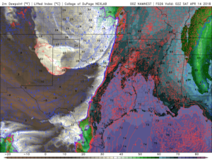
While there is a cap in place, the dewpoints in the 70s will mean we’ll be on the edge of something potentially breaking through the cap. The cap will try to keep activity out of the DFW region, however the dewpoints being as high as they will be will make conditions very muggy tomorrow, along with daytime heating could lead to some storms trying to fire up. Theres a possibility that one of these could break the cap if its strong enough, however this is NOT 100% guaranteed, theres still a high chance it holds leaving DFW with only a few showers. If the cap holds we’re fine, however if it becomes compromised we could see some issues (large hail baseball sized possible, damaging winds, and possibly a tornado or two). However again there is still a high likely hood it stays intact and our area stays dry-ish, while areas east will still see the brunt of the activity as the cap will be much weaker for areas east of DFW
Stay tuned for the latest. We should have a more detailed forecast posted tomorrow. ~weather225.com @weather225dfw
Leave a Reply