
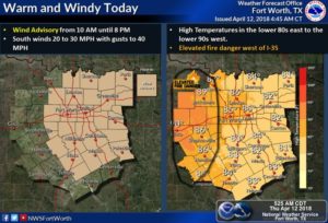
Good morning north Texas happy Thursday. A wind advisory is in effect until 10pm this evening for a large majority of NTX. An elevated fire weather risk will also exist for areas along and west of I-35 where temperatures will reach the upper 80s.
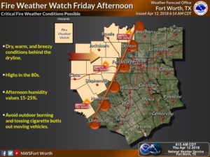
The Fire weather threat will continue through Friday for areas west of I-35 where a Fire Weather Watch is expected to be issued Friday afternoon as the approaching Dryline pushes through. Check your local counties website to find if your county has issued a burn ban.
Besides this fire weather threat, we’re still monitoring the threat for storms Friday. Thankfully it appears that our cap will protect our region from storm activity, keeping activity east of DFW. The SPC this morning has shifted the risk areas further east from Dallas. And moving the 3/5 further into east TX.
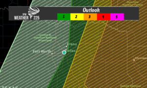
Storms east of DFW could produce very large hail, damaging winds, and a few tornadoes possible. Dew points Friday will be in the upper 60s to lower 70s, and conditions look to be very favorable for severe weather activity, so if our cap holds as expected, it should keep our area from experiencing any problems.
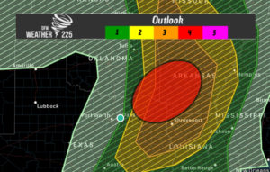
Conditions however look to be most favorable in the areas we’ve shadded in red across extreme north east TX, east/south eastern OK, and central western AR. Strong shear, and CAPE look supportive for rotating updrafts, supportive of large hail, and some tornadic activity. The SPC said areas south with higher CAPE levels (in the areas we’ve shadded red) could see “very large hail, damaging winds, and potential
for a few tornadoes exists — one or two of which may be strong.” And also say they could upgrade areas across AR to a Moderate (4/5) risk for storms in a later outlook. This has no effect on DFW, but is a good heads up for anyone who knows family in these areas, just to let them know they should stay weather aware tomorrow. Check back for the latest on our sites weather225.com and @weather225dfw
Leave a Reply