
A strong system is approaching the region, its obvious as winds will increase through Friday and stay near 30mph. The area will stay dry today and tomorrow, however the main show will be on Friday across the southern US, and possibly NTX. As of now the SPC has DFW under a 1/5 Marginal risk for storms Friday, and eastern parts of NTX under a 2/5 Slight risk, and all of East TX under a 3/5 Enhanced risk for storms Friday.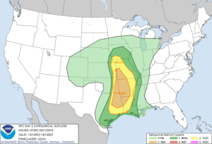 We do not like to hype up forecasts days in advanced just because there’s still some uncertainty, however the conditions over eastern TX and eastern OK where the cap will be weaker could see the chance to see a pretty significant weather event, as the upper level disturbance transitions into a negative tilt. We could very well see a severe weather outbreak across east TX, east OK, into the lower Ohio River Valley Friday afternoon and Friday night. So what does that mean for our area? AS OF NOW the cap looks like it should stay strong and hold over the metro area keeping storm development at bay across DFW, and keeping activity east where the cap is weaker, however, because there’s still some uncertainty we’ll be keeping an e on cap strength just incase its weaker than anticipated. For now though it looks like it should hold and keep us relatively dry in DFW. Areas east in the 3/5 risk should review their severe weather safety plans and keep an eye the forecast. Stay tuned
Copyright © 2024 | WordPress Theme by MH Themes
Leave a Reply