
The storm prediction center in Norman OK has placed an area or mesoscale discussion across parts of NTX where they anticipate a possible watch could be issued shortly for the development of severe weather this afternoon into this evening.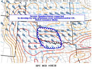 If a watch is issued it will most likely include all of our far north/red river counties. Storms will have the potential to produce large hail quarter sized or bigger, and damaging winds 60mph-70mph. Later this evening into early overnight we will monitor the complex of storms in OK and far north TX as they move south towards the DFW metro area. This will NOT be any major severe weather event, however its a good idea to make sure you have a way to receive warnings this afternoon into overnight. Stay tuned to our media outlets and track the activity using our free interactive radar on the main page of our website
Copyright © 2024 | WordPress Theme by MH Themes
Leave a Reply