
Good afternoon NTX. The WPC (Weather Prediction Center) has issued a rare HIGH risk for Flash Flooding, across parts of NTX this afternoon and tonight! These WPC outlooks are very similar to the Outlooks we mention often as these risks are issued rarely at a “high risk” and only if confidence is high that a life threatening flooding event may occur.
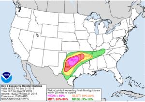
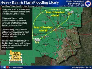
Around 1-5″ is likely with pockets of 6-10″ possible across parts of NTX. We could see some big impacts with area lake levels into next week as a result of this upcoming heavy rain, in addition to we could see local impacts of potential road closures and areal flooding in low lying areas, or areas prone to Flooding. The greatest areas at risk for this much rain will be for areas shaded bellow in the yellow. Flash Flood Watch in effect through Saturday Afternoon for almost all of north and central TX.
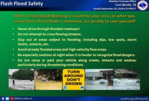
Please take some time before heading out to review these flood safety tips! Remember if you come across Flooding roads DONT RISK IT!!! Turn Around Don’t Drown! And always drive safely on the roads with water on them regardless! Don’t want to hydroplane!
 Stay tuned for the latest
Leave a Reply