
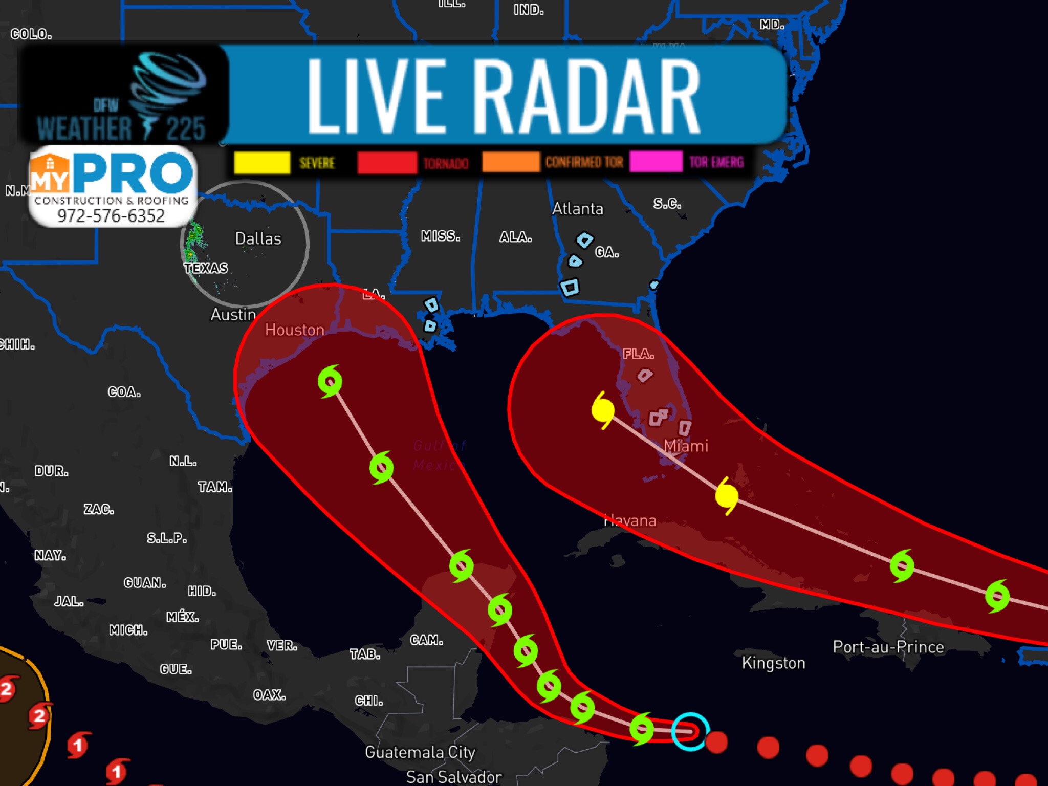
We currently have 2 systems we’re monitoring in parts of the Atlantic, and Gulf of Mexico.
The first system is located in the Central At,antic, and with its current path, has it moving West towards the Southern Florida coast, where it could impact the southern half of the state as a Hurricane by early Tuesday (as of current forecast path, stay tuned for updates).
The second system is currently located East of Puerto Lempira, and is expected to make its way North/Northwest towards the southern Florida coast roughly by Tuesday.
These are the current paths and forecasts for these two systems. Stay tuned for updates. The latest statement from the National Hurricane Center is located bellow.
Tropical Weather Discussion for North America, Central America
Gulf of Mexico, Caribbean Sea, northern sections of South
America, and Atlantic Ocean to the African coast from the
Equator to 32N. The following information is based on satellite
imagery, weather observations, radar and meteorological analysis.

Based on 1200 UTC surface analysis and satellite imagery through
1650 UTC.


Tropical Weather Discussion
NWS National Hurricane Center Miami FL
1250 PM EDT Thu Aug 20 2020

Tropical Weather Discussion for North America, Central America
Gulf of Mexico, Caribbean Sea, northern sections of South
America, and Atlantic Ocean to the African coast from the
Equator to 32N. The following information is based on satellite
imagery, weather observations, radar and meteorological analysis.

Based on 1200 UTC surface analysis and satellite imagery through
1700 UTC.

...SPECIAL FEATURES...

Tropical Depression Thirteen is centered near 16.0N 52.0W at
20/1500 UTC or 750 nm E of the Northern Leeward Islands moving
WNW at 18 kt. Estimated minimum central pressure is 1008 mb.
Maximum sustained wind speed is 30 kt with gusts to 40 kt.
Scattered moderate to isolated strong convection stretches from
180 nm in the NW quadrant and 160 nm in the southern semicircle.
Additional scattered moderate convection is seen 260 nm south of
the center between 51W to 53W. Seas are up to 10 ft near the
center. On the forecast track, the depression is expected to move
near or north of the northern Leeward Islands by late Friday and
near or north of the Virgin Islands and Puerto Rico on Saturday.
Please read the latest NHC Public Advisory at
https://www.nhc.noaa.gov/text/MIATCPAT3.shtml and
Forecast/Advisory at
https://www.nhc.noaa.gov/text/MIATCMAT3.shtml
for more details.


Tropical Depression Fourteen is centered near 15.1N 79.7W at
20/1500 UTC or 235 nm E of Cabo Gracias a Dios on Nicaragua
and Honduras border Moving W at 18 kt. Estimated minimum central
pressure is 1007 mb. Maximum sustained wind speed is 30 kt with
gusts to 40 kt. Numerous moderate to strong convection noted 300
nm in the northern semicircle and scattered moderate in the SE
quadrant. On the forecast track, the center of the system will
move near or just north of the northeastern coast of Honduras and
the Bay Islands on Friday and will approach the east coast of the
Yucatan Peninsula of Mexico on Saturday. The center is then
expected to cross the Yucatan Peninsula Saturday night and move
into the south-central Gulf of Mexico on Sunday. Please read the
latest NHC Public Advisory at
www.nhc.noaa.gov/text/MIATCPATA.shtml and
Forecast/Advisory at https://www.nhc.noaa.gov/text/MIATCMAT4.shtml
for more details.


A tropical wave over western Africa is producing disorganized
showers and thunderstorms near the Africa coast. This wave is
expected to move over the far eastern tropical Atlantic on Fri,
and some slow development is possible through the weekend while it
moves west-northwest at 15 to 20 mph across the eastern tropical
Atlantic. Scattered moderate convection is noted between 04N-12N
between 16W-20W along the African coast south of Guinea- Besau.
ASCAT pass shows fresh to strong southerly winds from 05N- 10N
between 14W-20W. Please refer to the latest NHC Tropical Weather
Outlook at www.hurricanes.gov, for more details.
Leave a Reply