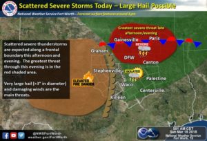
Today the threat for severe weather returns once again to the region. There wont be as widespread of coverage as there was yesterday with activity in ctx, however the few storms that develop north of I-20 will pose a very large hail threat (2-3″ in diameter!) along with a damaging wind threat, and a few tornadoes cannot be ruled out either, especially with any discrete cell. To be clear not everyone will see storms today. Timing looks to be from around 3pm to 8pm once again so mid late afternoon hours. Be sure to stay weather aware today, as previously mentioned not everyone will see storms, however any storm that develops could pose a great threat with the conditions supporting the risk for 3″ hail. Track the activity on our radar at weather225.com. And stay tuned to our media sites @weather225dfw
Copyright © 2024 | WordPress Theme by MH Themes


Leave a Reply