
Good Morning NTX and happy Friday. To start this forecast update on this afternoon and evenings storm potential, the SPC has upgraded areas from Dallas and off to the east to a (3/5) Enhanced Risk for storms as an unseasonably strong cold front and dryline enter the region this afternoon and evening.
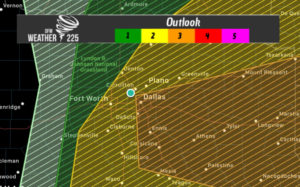 The rest of North Texas remains in a Slight (2/5) or Marginal (1/5) Risk. The threats accosiated with storms this afternoon and evening will be Damaging Winds, Large Hail, and possibly a spin up tornado or two. Overall Damaging Winds will be the primary threat tonight
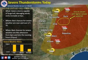
Overall timing looks to be from 4pm-11pm this evening for storm activity, and again the best storm chances exists for areas along and east of I-35.
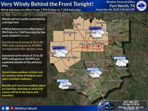
After the front passes, a Wind Advisory will be in effect until 7am Saturday. Sustained winds will be from 25-35 mph with gusts up to 40 at times. So be sure to strap down any loose yard furniture or loose items.
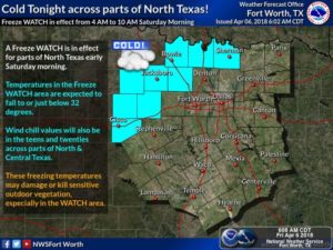
Also on top of the severe weather threat, areas north and north west of DFW are looking at possibly a freezing rain threat overnight into early Saturday! Yes you heard right, however THIS DOES NOT look like it should have any significant impacts. A freeze watch will be in effect for the areas shaded in blue in the graph bellow. Only in Texas can this type of weather be possible (eyes rolling)
Stay tuned here on weather225.com and to our media sites @weather225dfw for the latest incase anything changes.
Leave a Reply