
Good evening NTX. You may have heard somewhere online or on the news the “s” word in the forecast for tomorrow, and yes you heard right. Snow/sleet will be possible tomorrow afternoon and evening for parts of NTX mainly for areas from DFW and off to the west and north west.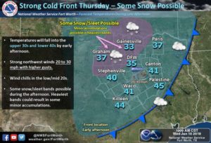 A strong cold front will push through the region tomorrow, strong winds will be likely as gusts are expected to be from 20-30mph+ at times. A wind advisory is in effect for tomorrow afternoon and evening for-
Montague-Cooke-Grayson-Fannin-Lamar-Young-Jack-Wise-Denton-Collin-Hunt-Delta-Hopkins-Stephens-Palo Pinto-Parker-Tarrant-Dallas-Rockwall-Kaufman-Van Zandt-Rains-Eastland-Erath-Hood-Somervell-Johnson-Ellis-Henderson-Comanche-Mills-Hamilton-Bosque-Hill-Navarro-Lampasas-Coryell-Bell-McLennan.
Along with gusty winds, temps are expected to fall into the 30s and 40s. Snow sleet mix will be likely in the evening hours across the areas shaded in pink in both graphs. Rain chances will be in place for much of eastern NTX throught the day, however winter precipitation is unlikely in those areas.
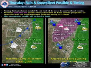 A big question some will be asking are travel conditions. Will this impact travel in anyway? We could see some minor travel issues tomorrow evening across the area from accumulation totals and near or at freezing temperatures. Nothing significant or major, however taking caution on the roadways is a good idea. Impacts should go away before Friday. Best times for winter weather activity should be from 2pm-7pm, and accumulations should be less than 1/2 of an inch
Leave a Reply