
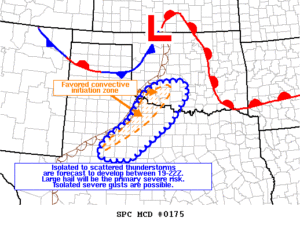
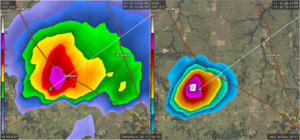
 The SPC has issued Mesoscale Discussion 175. This concerns the threat for isolated storm development over the afternoon and evening hours, and the potential threat for severe weather these storms may pose. The likely hood of a watch is very likely. As of 12:17pm we already have cells developing across Montague county that were starting to develop some intensifying hail cores. Stay tuned to NOAA weather radio and NWS as well as our pages for the latest information.
Discussion summary by SPC bellow-
Mesoscale Discussion 0175
NWS Storm Prediction Center Norman OK
1207 PM CDT Mon Mar 26 2018
Areas affected…Big Country of TX into western north-central TX and
into southwest OK
Concerning…Severe potential…Severe Thunderstorm Watch likely
Valid 261707Z – 261930Z
Probability of Watch Issuance…95 percent
SUMMARY…Isolated to scattered thunderstorms are forecast to
develop between 19-22Z. Large hail will be the primary severe risk.
Isolated severe gusts are possible.
DISCUSSION…Midday subjective surface mesoanalysis places a
southwest-northeast oriented dryline from the Permian Basin into
southwest OK and north into west-central OK. Temperatures range
from the lower-middle 80s degrees F near the US 83 corridor to the
lower 70s in central OK. Surface dewpoints range from the middle
60s in southwest OK to the lower 60s where temperatures are the
warmest and greatest mixing has occurred.
As the boundary layer continues to heat, the remaining weak
convective inhibition will continue to erode and convective
initiation is forecast in a general sense by mid afternoon
(19Z-20Z). A moderately unstable airmass (MLCAPE ranging from 1500
northeast to 2500 J/kg near the Red River) amidst a strong 0-6 km
shear (65 kt) will support an initial threat for supercells to
evolve with a risk for large to very large hail. Later in the
convective cycle, modification of the thermal profile coupled with
additional storms developing largely parallel to the dryline will
result in a gradual tempering of the hail threat. Isolated severe
gusts are also possible with the storms. The risk for a brief/weak
tornado will likely be minimized given the already observed
reduction in the low-level hodograph per KDYX and KFDR VAD data and
the models showing no hodograph enlargement given the veer-back-veer
wind profile here-forward.
..Smith/Grams.. 03/26/2018
…Please see www.spc.noaa.gov for graphic product…
ATTN…WFO…FWD…OUN…SJT…LUB…MAF…
LAT…LON 33449819 32059993 32000097 32210139 32770110 33530006
34609939 35029867 35059752 34669731 33449819
Leave a Reply