
Good evening north Texas, we have a few things to quickly mention before you head to bed tonight.
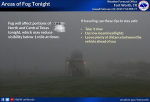
To start there is a chance for some showers and storms across the region tonight, the best activity will remain along and east of I-35 however, I believe the main activity will remain east of a line from Collin, Dallas, Kaufman, Rockwall, and Ellis counties to the east. That does NOT mean DFW will not see any storms, its a good idea to just stay weather aware overnight with some sort of way to receive weather warnings because there is a threat for hail and gusty winds with the strongest storms, but I do not anticipate any widespread severe weather activity (this doesn’t mean you need to stay up and watch the weather, we may not even see any storms, but its a good idea to have some way to receive warnings overnight just incase 🙂 ). Timing for any rain/storm activity would be between 12am-6am, that’s for all the region and areas east we cover, and once again the threat is very low for severe weather.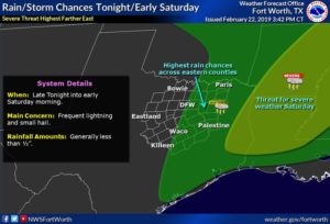 Areas of fog are also expected across the region over night, there are no advisories currently in effect for our viewing area, however there could be spots with visibility less than a mile, so be sure to drive carefully
(UPDATE ON the fog situation) Dense Fog Advisory is now in effect until 7am for-
Montague-Cooke-Grayson-Young-Jack-Wise-Denton-Collin-Stephens-
Palo Pinto-Parker-Tarrant-Dallas-Rockwall-Eastland-Erath-Hood- Somervell-Johnson-Comanche- Updated at 10:58pm CST
Another thing to mention would be a Wind Advisory issued for Montague-Cooke-Grayson-Young-Jack-Wise-Denton-Collin-Stephens-Palo Pinto-Parker-Tarrant-Dallas-Rockwall-Eastland-Erath-Hood-Somervell-Johnson-Comanche counties from 9am to 6pm Saturday. Wind gusts up to 40 possible, with sustained winds of 25-30mph likely.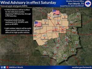 Have a good evening NTX, and good start to your weekend 🙂
Leave a Reply