
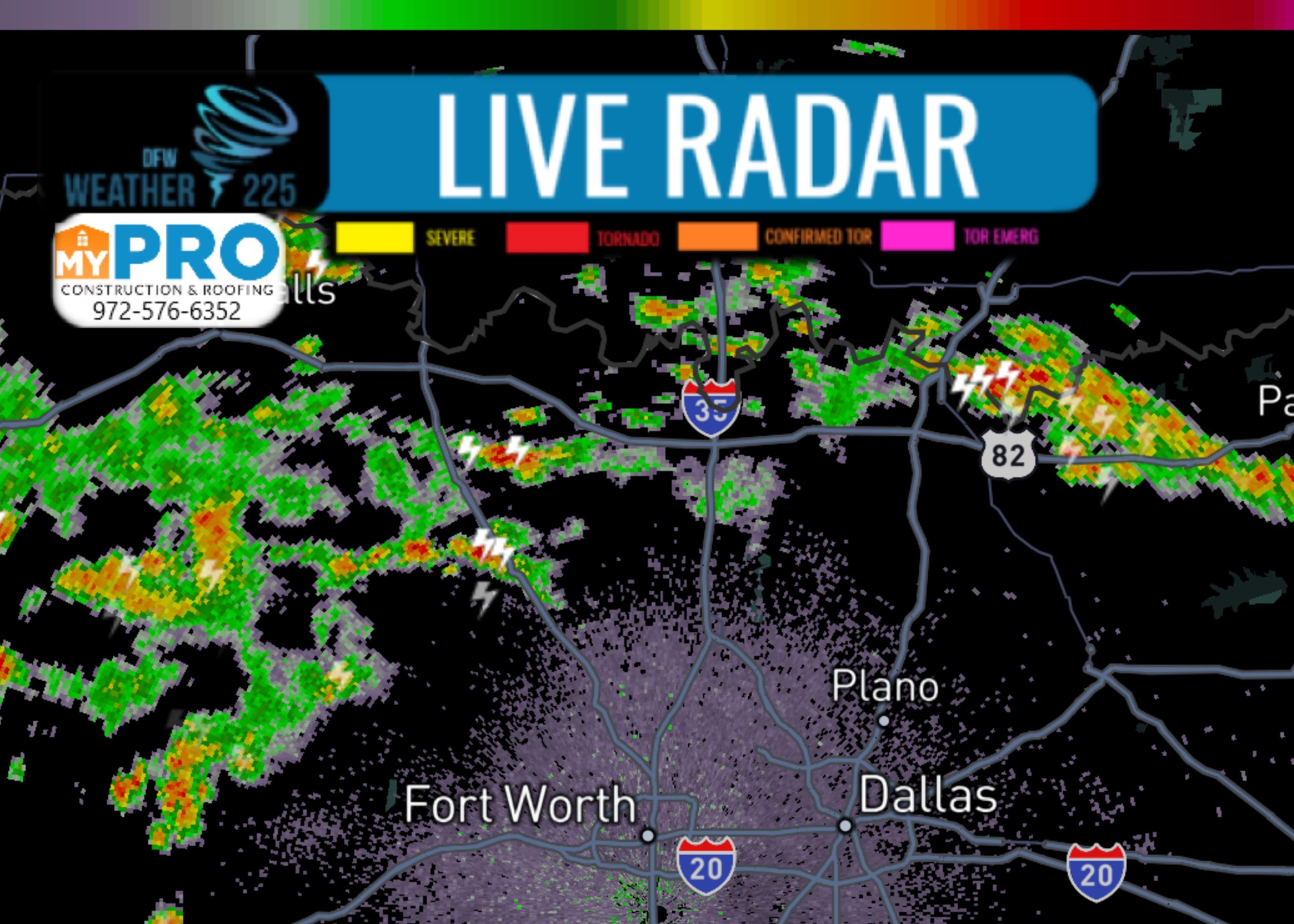
Good afternoon North Texas. we currently have patchy showers/storm activity across parts of the region at this time. The potential for heavy rainfall continues throughout the rest of the day for some areas.
The WPC (Weather Prediction Center) has placed a large portion of North Texas under a Precipitation Mesoscale Discussion. This is concerning the potential for up to 2-5” of rainfall with slow moving storms this afternoon. Their discussion is bellow.
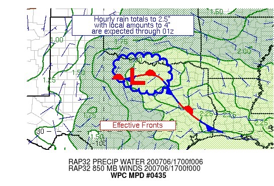
Mesoscale Precipitation Discussion 0435
NWS Weather Prediction Center College Park MD
318 PM EDT Mon Jul 06 2020

Areas affected...North-Central TX

Concerning...Heavy rainfall...Flash flooding possible

Valid 061916Z - 070116Z

Summary...Thunderstorms with heavy rainfall are expected over an
area that has seen some recent saturation.  Hourly amounts to 2.5"
and local amounts to 4" are anticipated.

Discussion...Thunderstorms have been developing across
North-Central TX as of late near and northwest of a warm core low.
 Precipitable water values are 1.7-2.1" per recent GPS data.
Instability across portions of the Red River of the South/the
TX-OK border is sufficient, with 2000+ J/kg values per recent SPC
mesoanalyses.  Effective bulk shear is <25 knots, which is leading
to pulse convection for the most part.  Inflow at 850 hPa is
modest, with east-northeast winds of 15 knots seen on recent VAD
wind profiles.  While run of the mill for summer, the mean 850-400
hPa winds are even lighter, on the order of 5 knots per NAM
forecasts.

The expectation is for pulse convection to shift from near and
west-southwest of the instability pool to south of the instability
with time as the warm core low nudges eastward.  The instability
pool itself may also nudge eastward due to daytime heating.  A
narrow axis in this area has experienced 2-3 times their average
two week precipitation, and some of the targeted area is urban,
leaving them potentially sensitive to heavy rainfall.  Morning
rains lowered flash flood guidance to 1.5-2.5" in three hours,
which would be surpassed locally in these thunderstorms.  The 12z
HREF probabilities of 1"+ an hour stay high (50%+) for the next
several hours, showing an east-southeast shift with time following
the expected movement of the low, the forward propagating
convective vectors, and is vaguely aligned with the 1000-500 hPa
thickness pattern.  Hourly rain totals to 2.5" and local amounts
to 4" are anticipated, which appears to be reasonably advertised
by the available mesoscale guidance, particularly the 12z ARW and
12z NSSL WRF.  The 17z HRRR appears too far north in placement.

Roth

ATTN...WFO...FWD...OUN...SJT...

ATTN...RFC...ABRFC...WGRFC...NWC...

LAT...LON   34229727 33709633 33129633 32469662 32319753
            32679850 33309923 34099905
Leave a Reply