San Antonio Texas- Significant Flash Flooding continues to impact the Texas Hill Country again today as a slow moving Mesoscale Convective System or “MCV” moves through the region.

This slow moving system combined with high moisture from the gulf, and additional moisture feeing into it overnight from the lower-level-jet has lead to nearly non-stop rainfall from Wednesday into Thursday.
Even worse there’s conditions favorable for more rainfall throughout the day Thursday, and potentially some more activity again Friday.
Some areas have received well over 10-15″ of rainfall, with other areas receiving nearly 30″ of rainfall.
This intense rainfall has lead to numerous considerable to catastrophic Flash Flood Warnings. “Catastrophic” warnings also known as Flash Flood Emergencies are rarely issued, and are only reserved for significant life threatening flash flooding.
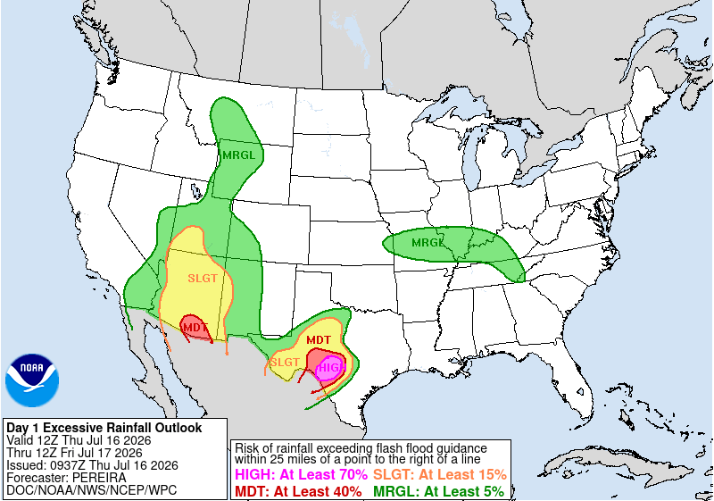
A rare 4/4 high risk for excessive rainfall was issued for today from the Weather Prediction Center across parts of the Texas Hill Country.
Their latest forecast discussion can be found below:
…THERE IS A HIGH RISK OF EXCESSIVE RAINFALL ACROSS PORTIONS OF
SOUTH-CENTRAL TEXAS…
…Texas…
A High Risk was introduced at 0930Z across portions
of south-central Texas. This includes areas where heavy rainfall
continues to fall and drift slowly to the north. Areas of slow-
moving, heavy rainfall are expected to continue beyond 12Z,
exacerbating the catastrophic impacts that unfolded across
portions of the region overnight. The Moderate Risk was also
expanded a little farther to the north to account for the current
trends.
Previous discussion…
The persistent convective pattern centered near the Edwards Plateau
and southern Hill Country is expected to enter its final high-
impact phase this period. The high-end Moderate Risk has been
maintained over south-central Texas, centering on a corridor from
Val Verde and Crockett counties eastward into the southern Hill
Country. Extremely compromised soil conditions from multi-day
rainfall and very low flash flood guidance mean any additional
precipitation will exacerbate ongoing flooding. Convection that has
developed early this morning will likely linger past daybreak
around a slow-moving MCV, followed by another anticipated round of
locally heavy nocturnal storms late Thursday night into early
Friday morning. Both the HREF and REFS show robust probabilities
for additional rainfall totals exceeding 3 inches, with localized
narrow bands potentially reaching over 5 inches.
Farther north, the Slight Risk was extended into portions of
Northwest Texas. This expansion is supported by deep moisture
pooling along a low-to-mid level boundary, combined with shortwave
energy lifting northward out of the main system, which will fuel
scattered, high-rate convective cores capable of localized runoff
concerns.
About the Author